
A little further on there was the group of Elk we had seen on previous mornings, but we decided to press on. At the Madison junction we turned right and headed south into the the Geyser Basin. The objective was to cover some of the areas we hadn't visited on our first day, so first up was a turn onto the Firehole Canyon Drive, the main attraction being the Firehole falls which we soon passed, at 40 feet not one of the highest falls we had seen, but impressive non the less as the water passes over the rhyolite rock of the Yellowstone caldera.

The drive passes a water hole that is popular for swimming, and then out onto the main road once again. Here there is a turn off that follows Nez Perce or Chief Joseph Creek. In this area the Nez Perce Indians fled from the US Army, led by Chief Joseph.

With the discovery of gold in 1877, the US government sent General Oliver Howard to force the Nez Perce to move to an Idaho reservation. Chief Joseph and his band left for the reservation, but before they could reach it, several Nez Perce youths, disillusioned by broken treaty promises and white encroachment on their land, attacked and killed 18 white settlers.
Chief Joseph then began a three month, 1,600 miles flight to Canada with four separate U.S. military units in pursuit. Chief Joseph and his party repeatedly turned the tables on numerically superior forces. They eluded and out-fought 2,000 Army soldiers in 13 battles before finally surrendering in a Montana snowstorm, just 40 miles from the Canadian border.
That journey took them through the park at Madison River, down here across Firehole Creek, and then out towards Pelican Creek where we were yesterday. Only 418 men, women, and children out of 800 who had set out finished the journey in Montana. Under the terms of the surrender, the Nez Perce were promised that they could live on a reservation in Lapwai, Idaho. But instead the Nez Perce were sent to Oklahoma. The surrender of Chief Joseph of the Nez Perce ended a decade of warfare between Indians and the U.S. government in the Far West. It meant that virtually all western Indians had been forced to live on government reservations.
Back on the main road we continued south, but pulled into the area of the Fountain Paint Pot nature trail, and area that takes in four types of thermal feature. The boardwalk leads through an area of dead trees in amongst grey white silt deposits.

The first feature was Silex Spring which due to the cool conditions was covered in steam and mist as it bubbled out hot water.

With the weak sunshine due to the overcast conditions, and the heavy steam and mist once again it was creating lovely landscape features in the pine trees.

Fountain Paint Pot is actually a collection bubbling mud, the largest in the park, however by August the activity is much reduced. Next was Red Spouter, that in the spring acts like a mud pot, only to turn into a fumarole in late summer, which is exactly what we found today.

This feature only appeared after an earthquake in 1959. The next geyser is also linked to the 1959 earthquake as it has erupted constantly since then. It is known as the Clepsydra Geyser, named after the Greek for "water clock".

The area beyond the geysers s been flooded with deposits and in many places now supports rich grassland that supports one of the park's largest buffalo herds, although we couldn't see any!

The final hydro-thermal activity on the trail was provided by the Celestine Pool.

The moving steam, the weak sunshine plus the clear water all transpiring to create some amazing atmospheres.


Leaving the Paint Pots we carried on but almost immediately turned off onto Firehole Lake Drive. Almost immediately we pulled over for a breakfast stop, looking out the area was just full of pools and large geysers.

having eaten our yoghurt and bagel we set off only to immediately pull over, this was Great Fountain Geyser, one of the most impressive geysers in the park. It can soar up to 200 feet in the air. A sign predicted an eruption between 4.00 am and 8.00 am, it was just before 8.00 am would be lucky as there was some activity in the crater?

However as we walked past the benches, provided for onlookers the area was very wet, and it seemed as if we had missed it. Moving back to the road the reflection in the pools created around the geyser were wonderful.


The drive continues for about three miles past other geysers, and steaming streams and pools in amongst the the White Dome Geyser and Firehole Lake.

There was not much wild life about, but we did see a Spotted Sandpiper by the side of one of the steaming streams.
Back on the main road our next stop was the Midway Geyser Basin. As we approached the geyser area you could see the run off from the geysers tumbling into the Firehole River. More water is discharged here in a single day than Old Faithful releases in two months, it is estimated that 4000 gallons of boiling water flows into the river every minute.

The yellow and orange colours created by the algae and bacteria that live in the warm water conditions.
We walked past Excelsior Pool, a huge geyser that blew out of existence in the 1880s, the last eruptions here were in 1985. The large crater was covered in steam from the constantly moving boiling water that was being discharged into the river so it was hard to see the pool itself.
The key feature here though is the Grand Prismatic Spring. This is the park's largest and deepest spring at 370 feet wide and 121 feet deep.

Above the pool was a multicoloured mist, dominated though by a blue haze.

The orange and yellow colours are created by bacteria living on the mat. The colours are then varied by other bacteria as they seek to produce photosynthesising cells to combat the strength of the sun.

The surrounding landscape also plays a part in creating the colours.

With no shelter for any trees in the area the bacteria are exposed to the sunshine, and have adapted resulting in the different patterns seen in the wonderful bacterial mats.

The water running off the pool was also creating remarkable reflections of the distant blue sky and clouds.

Leaving the basin we crossed the Firehole River once again, complete with its own set of small geysers and fumaroles.

The blue skies we were seeing to the west were being replaced by dark grey clouds to the south. We stopped off at the Old Faithful Inn for a coffee, and were treated to a couple of very close lightening strikes and loud claps of thunder. After the rain eased off we set off, heading for the West Thumb area of the the Lake, and then out over the Fishing Bridge towards the East Entrance. The journey was carried out through dark grey skies with rain every so often. As we passed we considered the Wets Thumb Geyser basin, but it was crowded with many people doing the same thing so we continued on.
At Pelican Creek we paused to scan the area, but apart from a calling juvenile Bald Eagle it was very quiet. There are two bays of the lake that are considered good for birds and waterfowl, namely Mary Bay and Sedge Bay, these being formed by the craters of thermal explosions, underwater the area is also one of the warmest areas in the lake with many underwater fumaroles. This probably accounts for the good numbers of birds that collect in the bays, but today all that were present were rafts of distant Goldeneye.
We turned off the road and climbed up the Lake Butte Overlook, and from here we could see the rain clouds over the lake, and completely different view from what we had been having over the last few days.

the road then climbs up to Sylvan Pass in the Absaroka Range, at its highest it reaches 10,937 feet. To the east of the pass we pass through several valleys and then down to the east entrance and out onto the Buffalo Bill Scenic Highway.
However just outside the park there is a lodge called the Pahaska Tepee Resort, the original lodge being built by Buffalo Bill, and as we came down the hill we could see people parking and rushing from their cars. I slowed, and as we passed I could see the reason, a Moose feeding in the water by the side of the road. I quickly parked and got out of the car.

It seemed completely unfazed by the presence of a lot of people waving cameras, phones and iPads at it, and continued to munch away on what every vegetation it was eating from the water, the water dripping off its long muzzle.
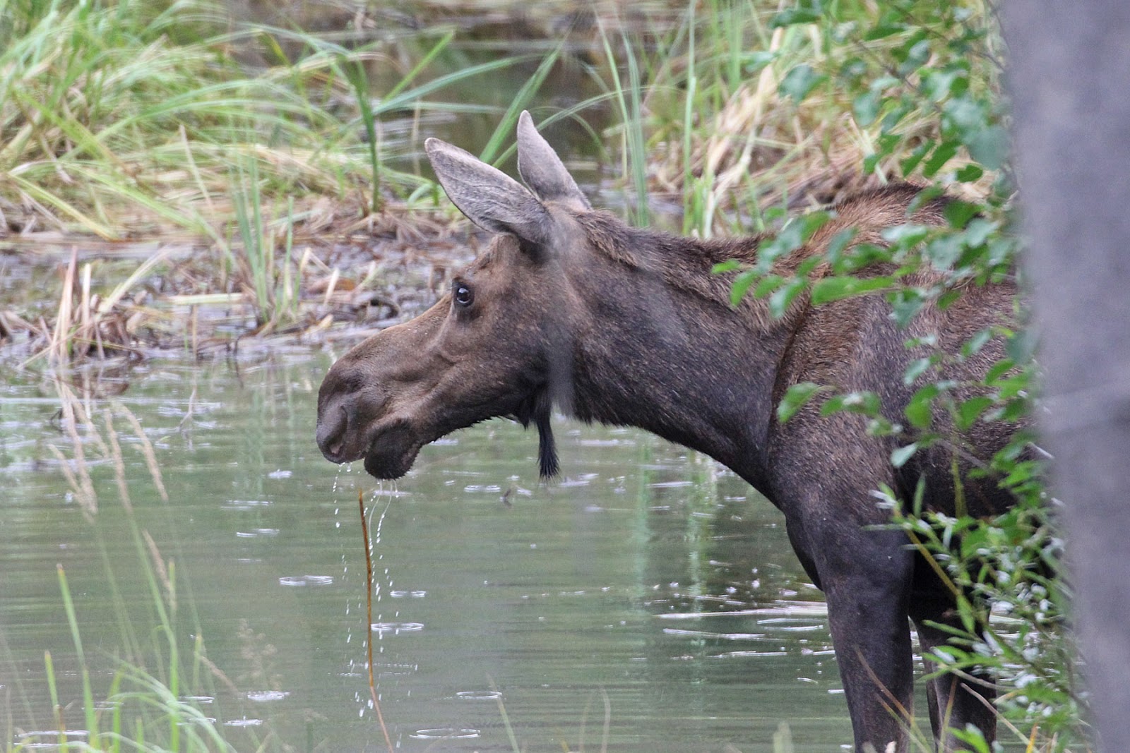
It was nice to see Moose, and ironic that we managed to find one just outside the park.
Our journey now would take us to Cody, about a 50 odd mile ride through the Wapiti Valley of the Shoshone River. The scenery was dramatic, but unfortunately the weather was dull and still drizzly. As we made our way around the canyons and cliffs I hoped that when we returned in a couple of days the weather would be better.
Six mile out of Cody we passed the Buffalo Bill Reservoir, and then the road enters Shoshone Canyon and goes through a tunnel, from there it is down hill into Cody.
As we pulled in to Cody the skies were grey, there was a wind blowing and a storm seemed likely. In addition we wondered what we were arriving into. On both sides of the roads there were car lots and strip malls, we passed Walmart and suddenly it didn't seem like a holiday location we wanted to be in.
The spirit of showman Buffalo Bill still thrives in the town that he promoted with a real estate speculator Geoff Beck in 1901. beck and his backers milked Bill's name and attracted the railroad and lobbied for the Shoshone dam. As we passed the signs Cody seemed like a farce, corny cowboy themes everywhere.
After attempting to check in only to be told we were too early we were at a loose end, so we decided to go the the Buffalo Bill Museum of the Wild West. I suppose we were not sure what to expect but came out after having thoroughly enjoying the time there. The museum presents a wealth of fascinating information on the life of William J Cody and his wild west shows. In addition there was an excellent museum on the Plains Indians in which their culture and struggles with the arrival of the white man. There was also a art exhibition, and Natural History exhibit, and a section on guns that we decided not to visit.
We decided to go out late afternoon to walk the main street and shops, and ended up in the Irma Hotel, which was built in 1902 by Buffalo Bill and named after his daughter Irma.

The hotel's most famous feature is the 50 foot imported French Cherrywood bar, which can be found in the dining room. It was present to Bill by Queen Victoria, and transported by stagecoach from Red Lodge at a cost of $100,000 more than the value of the hotel.

While enjoying a drink in the Irma we were treated to a gunfight in the street outside, something laid on for the tourists as a way of collecting for charity it was an entertaining end to another day, and it seemed that Cody was beginning to change our opinions of it. Despite the showmanship and cowboy themes it felt like the wild west with folks chatting in doorways, and cowboys wore Stetson hats.

No comments:
Post a Comment